Day 61 & 62: Sanford Island to Milford Haven to Sault Ste. Marie (The Soo)
Day 61: September 17: Oh Lake Huron! Many thanks for resting so calmly, your vast waters touching the sky as far as we can see. I will forever keep this vision in my mind. I wish I had the right words to describe what I am looking at.


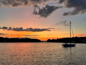
We left Sanford Island area at 10:00 a.m. and traveled 44 miles in about 5 1/2 hours, continuing on the north shore of Huron. Although I'm sure we would have had a fantastic trip had we ventured deeper in the lake, cruising between the islands in the north channel ensured an even calmer cruise. A NW wind blew between 7 and 8 knots throughout the voyage. We passed by Blind River and Thessalon on our starboard and Drummond Island on our port before turning to port to Milford Haven on the southeast end of St. Joseph Island. We were alone in the anchorage until a sailboat motored in and dropped anchor off our bow. Flying the Canadian flag, we assume, perhaps incorrectly, that they are familiar with this spot.

Milford is a long, deep anchorage that provides great protection from anything other than SSW and beautiful scenery. It feels a bit more remote than others we have stayed in. There is a rustic looking boathouse in front of what looked like some sort of ruins. Tied to a dock was what looked like a homemade cabin cruiser. We wanted to explore the shore but we caught a glimpse of a house through the woods. Chances are the house was closed up for the season but we didn't want to trespass on someone's property so opted to settle in on the boat. It was probably a good thing that we didn't set out on the dinghy because the wind picked up pretty quickly, ushering in cold temperatures and a bit of chop. Sandra needed to rest but David joined us for dinner of grilled steaks, rice and gnocchi topped off with a bit of ice cream!

Day 62: September 18: It's a little overcast this morning but once again no wind to speak of is predicted. As we have found on this trip, there is beauty in all kinds of weather; clouds, sun, wind or rain. We marvel at it all.

We pulled up anchor at about 8:30 and traveled 44 miles in about 5 1/2 hours up St. Marys River until we got to Sault Ste. Marie (the Soo). We had spoken to our son A.J. who was once stationed here when he was in the Coast Guard. He was a wealth of information about the river and its islands and alerted us to the fact that there is an upbound and downbound channel; the up being on the east side of Neebish Island while the downbound travels on the west side.
It was a glorious trip along the river with the sparkling water shining like diamonds as the bright sun shone on it. Here are some of the sights we saw along the way. We thought the house on the left with the red roof, flying an American and a Canadian flag as well as a Coast Guard flag had something to do with the CG but we found out it was just someone's house. The middle picture is Lime Island; a place used by the Coast Guard to store equipment. On the shore were several very large buoys. The red and green buoys mark where the channel splits into two.


Along the river are numerous range or leading lights. They are a pair of light beacons used in navigation to indicate a safe passage for vessels entering a shallow or dangerous channel. They can also be used for position. These special markers allow the huge tankers/lakers to see the channels.


It wasn't long after we entered St. Marys River when we sighted lakers. One (the Federal Bering) was following the same path as we were so we kept our eye on her as she began to overtake us. The captain radioed John to make sure a safe passage was made. John turned a bit toward port to allow plenty of room for the giant of the lakes to pass by on our starboard side. It's something to watch such huge vessels travel pretty quickly. John looked on the AIS and noted she was traveling about 13 knots. You definitely want to make way!


As we approached George Kemp Marina in the Soo, the wind picked up a bit. Combined with the current near the locks, it was a bit difficult to pull into the marina. Zendeavor and we took on some fuel before backing into our slips with the help of two dock hands. It was fun to be back in the Soo and see the Katmaibay (ice breaker 101) as well as the Mackinaw. It was pretty special to be docked right near both of them. Aj served on the Kat; we had a chance to tour her years ago when he was stationed here. The Mackinaw is the "Pride of the Great Lakes". she is the Coast Guard's only heavy icebreaker on lakes, distinguishable by her red hull. She replaced the CGC Mackinaw who served on the lakes for over 60 years. As evening approached, the ships looked even more beautiful with their lights cutting through the night sky.


I mentioned this on FB that if your journey takes you anywhere near Leland, MI.please stop in to my dear friend Ricks “The Cove” restaurant! It a neat, eclectic(decor) waterfront restaurant that could probably tie right up to. Rick and his sons Sean and Christopher have owned and operated it for many years. If by chance this is on your route please text me @ 239-370-0583 and I’ll take care of everything! Sante’
ReplyDeleteDoug Amaral
That is very kind of you! I'll let you know where our travels take us.
Delete