Day 100: Travel to Kaskaskia Bend
Day 100: October 26: It was a drizzly morning but the temps were still comfortable enough to not require sweatshirts! We called the MelPrice Lock lockmaster early in the morning, hoping to get UW about 6:30 am. This lock is the first lock on the Upper Mississippi River. It has two chambers and floating bollards. He told us it was a good time to come so we left the dock and headed out from Alton Marina. Turning around I saw the bridge near just outside the marina bidding farewell.

Despite the lockmaster telling us to head toward the lock, we ended up idling in the river for about an hour. It turned out a northbound tug was in the lock; once a tug was in a lock it can take quite awhile before the lock is ready for other vessels. Before long we could see 5 other boats leave the marina; all 7 vessels continued to float around waiting for the green light. On a positive note we watched the sky become more glorious by the moment as the sun announced its daily presence.


Eventually the tug emerged and we watched it slowly make its way upriver; all 7 boats proceeded into the lock and tied to a bollard. This lock's lift is 23 feet.
 |
| A floating bollard |
When we exited one of the large boats put pedal to the metal, passing us on our port pretty quickly. That is not the usual process so we were a bit surprised. We found out later on that the boat was being driven by a captain hired to deliver it to a port unknown. These folks are always in a hurry as time is money. But in my opinion there is still a need to be respectful on the water.
We traveled about 5 miles before coming upon the junction of the Missouri and Upper Mississippi Rivers at Mile 195.3. Our next landmark was the Chain of Rocks Canal at Mile 195, a canal bypass just below the confluence of the Mississippi and Missouri Rivers adjacent to Duck Island before St. Louis. There is usually a lot of turbulence between the Missouri and the Chain of Rocks Canal. AGLCA members have been warned numerous times about the need to turn to port toward the Chain of Rocks lock (our second and final lock on the Mississippi). Under no circumstances should you turn to starboard as someone driving a sailboat did in 2021. This leads toward the Chain of Rocks which is a series of boulders that create a river wide set of white-water rapids. This huge mistake ended in disaster for the sailboat when it crashed against the rocks and was completely destroyed. I'm still unclear as to how this happened as the route is clearly marked.

There was a tug and barge traveling ahead of us in the canal, resulting in the pleasure crafts having to slow down to about 4 or 5 knots as well as pull back and idle so as not to come up beside the tug. Unfortunately the wind was gusting at 20 knots, making it difficult to stay in line. This went on for quite awhile; all 7 boats creeping through the narrow, turbulent channel. Eventually we were contacted by the lockmaster who told us we could speed up and pass the tug as he was going to put us into a separate chamber. We were grateful to be able to get on our way, rejoining the main canal.
At Mile 180 we came upon the famous Gateway Arch in St. Louis, the second largest city on our voyage down the Upper Mississippi. As we approached the Martin Luther King Bridge, the beautiful arch towered in the distance.
 |
| Zendeavor passing the Martin Luther Bridge |
This is a fascinating sight; the arch along with the capital in the background is pretty cool! Of course we wanted to have our pictures taken floating by in front of the Gateway Arch. This iconic structure is 630 feet tall; built in the 1960's it honors early 19th century explorations of Lewis and Clark and America's westward expansion in general.
Our plan was for Zendeaor to slide by while we snapped her picture then take our turn. This is easier said then done in a very busy, turbulent area. The water was riled and tows and barges were moving up and down along with the other Looper boats that had followed us out of the lock. Tows and barges also become camouflaged amongst vessels that are tied up making it difficult to spot straight away. With great care we managed!


 |
| Hoppies Marina |


Here are a couple of other interesting pictures I snapped! Beautiful colors and of course the working folks on the river. We continue to be amazed at the amount of commercial traffic on water and land.


The Jerry Costello (Kaskaskia) lock and dam is located at Mile 117.5. The Kaskaskia River meets the Mississippi River at this point. Under previous conditions a free dock was provided here. Unfortunately, due to dredging, access to the wall has been limited this year. Before we left Alton this morning we knew the wall would be off limits today; it will be available tomorrow (Friday) through Sunday and then completely shut down after that.
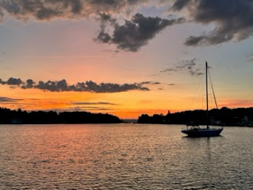
By the time we reached the Kaskaskia area it was getting late. At 5:30 and with sunset approaching we had to find an anchorage, which can be tricky along these rivers. Waterway Guide and Navionics apps, along with watching depths on the Chartplotter are great resources when searching for a good spot to drop the hook. Going south from the Kaskaskia lock where the river bends is where we found the perfect spot, a good distance from the channel with depths of about 12 feet. We dropped anchor and settled in for a peaceful night. With an overcast sky the sunset was still something to behold, turning water and sky alike a pale pink.


Comments
Post a Comment