Day 141: December 6: A beautiful morning and a great day to travel.
After morning coffee and some necessary chatting we pulled up anchor and started the day's voyage at 7:30 a.m.
We passed by Archie's house sitting high above on the bluff and continued slowly along the narrow waterway. It took us about an hour to travel the 6.1 NM to the where the oxbow meets the Tombigbee.

Mile marker 217 marks the official end of the Tenn-Tom and the beginning of the Black Warrior-Tombigbee Waterway which stretches from Mobile, AL to the headwaters of the Mulberry Fork, a tributary of the Black Warrior River. This 430 mile waterway is older than the more well known Tenn-Tom. Between 1888 and 1915 a total of 17 locks and dams were built on this waterway to make it navigable. Thirteen of these locks and dams were located up the Black Warrior River from where it joins the Tombigbee at Mile 217. Over time, 4 taller locks replaced the 13. smaller ones. South of Mile 217 the Tombigbee and Alabama Rivers connect at Mile 45 to form the Mobile River. Originally there were four locks on this 217-mile stretch until two taller locks, the Demopolis and Coffeeville, replaced them. We will travel through the Demopolis today!
All 3 boats pulled into Kingfisher Bay Marina in Demopolis, AL where we took on water and fuel, disposed of our trash and pumped out. The marina has a courtesy car but it's only available to boaters who stay for the night. The lady managing the dock area contacted a friend (Meri) who works 2 days a week at the marina; she provides rides to folks who need to get to a store to provision. She arrived in her van and Sandra, Mona and I piled in. Meanwhile the marina allowed us to raft at the end of a T dock for a couple of hours while we did our groceries.
We contacted the Demopolis Lock which is located about 2 miles from the marina and were told the lock would be ready for us as no commercial traffic was in the area. We locked through with ease, after all we must be experts by now. Exiting the lock, we looked back; the dam's rushing water cascading over the wall created a stunning view.
Travel highlights for the day included the remains of the old Rooster Bridge. this was the bridge where the tugboat Cahaba was capsized and pushed under during a flood in April 1979. Unbelievably, the tug somehow popped up on the other side of the bridge and continued on its cruise under its own power.
The second highlight was seeing more beautiful white cliffs that stretch for 5 to 6 miles along the Black Warrior-Tombigbee. Though not as majestic as the White Cliffs of Epes, they added so much beauty to the waterway. And of course the occasional tow passed us by.


It was getting late and we needed to get to one of the few good anchorages that are available in this stretch of the waterway before dark. We contacted a few Loopers we saw anchored at Edna Bend to ask if they thought there was room for the 3 of us. They were a little hesitant, thinking there was only space enough for 1 more boat and suggested there might be a better spot a bit further up. We wanted to check out the spot for ourselves so we kept rolling, anxious to get settled before dark.
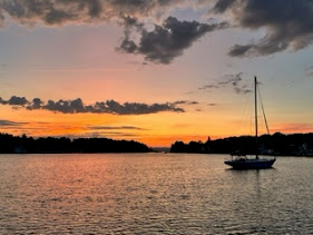
Edna Bend is situated along a sandbar on a pretty good bend in the river. Depths are good even close to the edge of the bar. Although it is out of the channel, we were still concerned about tows and barges being able to safely make a wide enough turn around the corner. Two other Loopers, Dos Gatos Locos and Dirtless were already anchored and rafted a bit further north of the sandbar and we didn't want to crowd them but we felt there was enough room for us as well. As it turned out we saw an approaching barge on AIS so we contacted the captain to let him know we were planning on anchoring for the night but we would idle in the area to see if he saw any problems with the spot we chose. We watched as the barge came through, making the turn with no problem. The captain radioed his appreciation and opined that we would be okay for the night. So we dropped anchor, rafted and out of an abundance of caution, David left his AIS and his bright blue lights on throughout the night.

Today we traveled 45.7 NM in 6 hours, continuing to wind our way south.


Comments
Post a Comment