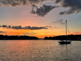
Day 208: Anchor in Mile Hammock Bay, NC
Day 208: May 10: Having had another troublesome night, we were delighted to see the sunrise. It's been chilly so we are back in light sweatshirts. Picked up the anchor at about 7:00 a.m. and headed north. We reached Southport, NC, a busy little harbor leading into Snows Cut at the Carolina Beach Inlet.


Just beyond Snows Cut, the Army's Military Ocean Terminal at Sunny Point can be seen on the west side of the Cape Fear River. This is a restricted area protected by a security barrier marked by 45 dolphins connected with cables. It is patrolled and obviously off limits to all but authorized personnel. It seemed to stretch for miles.

At Mile 283.1 we approached the Wrightsville Beach Bridge, vertical clearance 13', located right at the edge of Wrightsville Marina. The bridge only opens on the hour so timing is critical given how busy the area is. With marinas on both sides of the narrow channel, idling for any length of time can be quite tricky with small boats darting back and forth, high winds and strong currents. Having arrived about 45 minutes prior to the next opening, we turned around and traveled back up the river rather than try to idle in this very challenging spot.
At 1:00 p.m. the bridge opened and we, along with 3 other boats passed through. The bridge-tender watched from his vantage point, smiling and waving.


Located at Mile 278.1, the Figure Island Swing Bridge was listed as having a vertical clearance of 20'. We require 22' so requested an opening. The bridget-ender responded that the current clearance was 24', allowing us to pass under with no trouble.
At one point we were hailed by another Grand Banks traveling in the opposite direction. To our surprise it was a fellow Westporter. Tom Mayer, a friend of Craig's who has recently purchased a 1985 GB. He and some companions were transporting it from Florida to Westport. It was fun to run into him and see this beauty.


Here are a few pictures of interest I snapped along the way. The first 3 I refer to as "The Watchers"; an eagle, giraffe and osprey, all standing guard along the river banks.


We arrived at Mile Hammock Bay, a basin dredged out by military for use with Camp LeJeune, a 246-square-mile Marine Corps training facility in Jacksonville, NC. It is a popular anchorage located between Moorehead city and Wrightsville Beach. The shoreline is restricted military property but the anchorage basin is quite expansive and very heavily used by boaters.
We pulled in, joining 11 fellow boaters, No sooner had we dropped the hook, when we saw an ominous looking, huge shelf cloud rapidly approaching overhead. I have never seen anything like it and was certainly unnerved. Everyone in the anchorage scrambled to batten down the hatches and prepare for what nature had in store.


Within seconds the wind roared, accompanied by thunder, lightening and torrential rain. Every boat started spinning, being tossed around by the tremendous gusts. Thankfully our anchor held. Two other boaters' anchors either dragged or they simply wanted to reset so they started milling around, looking for a better spot. One of them drove in and out of the others for about an hour. I was so grateful when the storm finally passed by and we were still secure and safe. After traveling 75 NM in about 11 hours, we were looking forward to a peaceful night,


Comments
Post a Comment