Day 68: Touring Mackinac Island
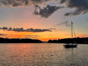
Day 68: September 24: Despite a rough start to our visit to Mackinaw Island, the sunrise didn't disappoint. As they say, the sun will come out....tomorrow! And it did.


David texted us around 6:30 a.m. to let us know he would be ready to help us get into a slip. We didn't waste any time as the wind had decreased enough for us to make the move. Additionally, no ferries were running so early in the morning so the time was right. We let the mooring ball go and headed into the dock and successfully tied up with a little help from our friends.
We've been looking forward to visiting the island, home to historic Fort Mackinac, Fort Holmes, several state parks, lovely scenery, quaint houses, geological formations and fudge! Car free for more than a century, the island's only mode of transportation is by bicycle or horse drawn carriage, adding to the appeal of the island. The main street is busy with bikes, pedestrians and horses. Without the roar of car engines or honking horns you can tune in to other sounds such as the hum of the wind or the hear gentle clip-clop of horses' hooves.
The Anishinaabe people who lived in the Straits of Mackinac region felt the island was shaped like a turtle so they named it "Mitchimakinak" which means "Big Turtle". When the last of the glaciers melted about 11,000 years ago ancient Lake Algonquin filled to a depth of about 220 feet higher than Lake Huron, hiding all the of the island except its highest point which was 1/2 mile long and about 1/4 mile wide. Native Americans thought it resembled a giant turtle.

Once docked, a hot cup of coffee and a bite of breakfast hit the spot! John and I took a quick walk to the edge of the corner where the "down town" starts right up from the marina. Just above the marina is Fort Mackinac which towers over Mackinac Island's Marquette Park. We stopped to admire Lady Liberty, gifted to the island in 1950 from the Boy Scouts of America in celebration of its 40th anniversary with the theme of "Strengthen the Arm of Liberty". She received a much needed restoration in 2012 due in part to the fundraising efforts of the Mackinac Island American Legion Post 299.


Mile marker 0 is located right at the park; it begins the 8.2 mile route along highway M-185 (also known as Lake Shore Boulevard) that circles the outer rim of the island. Highway M-185 is the only highway in the nation where vehicles are prohibited; it takes you through picturesque landscape views of the lake, geological formations, heavily wooded areas and historical sites. Being the first time on the much talked about Mackinac Island, we didn't waste any time getting the bikes out. Our trip began with a ride through the main downtown area. We were surprised by the amount of people walking, riding bikes or touring in the horse drawn carriages since it is pretty late in the season. I can not imagine the congestion on this main street during the summer months as it was very busy even in the end of September. How on earth do hundreds of bicycles pass along amidst the horses and carriages?


Sandra, David, John and I stopped at the Green Turtle Distillery and Brewery for a drink in the afternoon. Always on the lookout for a good local craft beer, I tried M-43 IPA. Brewed by the Old Nation Brewing Company, it was a great choice. The combination of several hops with tropical hints of pineapple, mango and grapefruit was perfect! This was followed by an early dinner at the well known Pink Pony.


Comments
Post a Comment