Day 101: October 27: It was a very peaceful night. We read that is is supposed to be warm today, maybe 80 degrees. Full of happy thoughts and great expectations, we got UW at 8:30 am, leaving what turned out to be a great anchorage at Kaskaskia Bend.
I put the coordinates for Little Diversion Canal (N 37.15.04, W 89.31.04) into the Chart Plotter as I usually do every day. Once into the plotter, the route is established and autopilot does the rest. Unless we are dodging a tow or deadhead or want to use the compass heading instead, autopilot is the way to go!
While it wasn't as cold as it could have been, the cloud cover certainly prevented the temps from getting anywhere 80. A couple of layers including sweatshirts were still a necessity.
One of the first things we saw along the river was a state penitentiary; Chester Prison; surrounded by fencing and guard towers. Imagine "living" on the water and not being able to enjoy it!
The Muddy Mississippi did not fail to live up to its reputation. Barge traffic continued to be heavy, contributing to the turbulence especially in areas where the channel narrowed or where bendway weir dams lined the shore. Not to repeat myself, but we continue to marvel at the amount of commerce along the entire river. Unless you see it you can't imagine it; day and night the work, including dredging, goes on.
Markers on bridges show how low the river system is right now. This bridge shows a clearance difference from 80 to 30 feet. Huge amounts of sand and debris also line the shore, calling attention to another time when the river was at its max. The Mississippi has the world's fourth largest drainage basin (watershed or catchment). It covers more than 1,245,000 square miles including all of parts of the U.S. states and two Canadian provinces and empties into the Gulf of Mexico. It looks like just about all of it has managed to empty out, resulting in more and more dredging.
Huge amounts of sand as well as trees and other debris line the shore, highlighting how high the river has risen at other times. We spotted a sailboat stranded way up on shore, looking like it was placed there on stanchions made of stone and logs. Perhaps we found Gilligan's Island.
We noted that this area is part of the Shawnee National Forest which consists of approximately 280,000 acres of federally managed lands. It lies between the Mississippi and Ohio Rivers in southern Illinois. Its terrain spans woodlands, hills and lakes and is home to a variety of wildlife including the majestic bald eagle.
We eventually traveled under the Bill Emerson Memorial Bridge at Mile 51.5; it connects Missouri to Illinois between Cape Girardeau, Missouri and East Cape Girardeau, Illinois. We knew our destination was just around the corner once we passed the bridge and a huge sign announcing we had arrived in
Cape Girardeau.
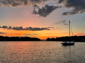
Just 2.5 miles beyond the bridge, we turned to starboard into Little Diversion Channel. It's a very popular spot, offering a well-protected, safe 10-foot deep water anchorage. Completely off the river and out of the channel, it is probably one of the safest anchorages on this stretch of the Mississippi. No sooner did we pull in and drop the hook, a barge passed by at the entrance.
We noticed tons of fish, probably carp, very close to the surface. David and Sandra dinghied over to our boat, trying to create enough of a disturbance to cause them to jump but it seemed their small engine was not strong enough. We chatted for awhile before settling in for another chilly, drizzly night.
Underway for just over 6 hours, we traveled 58 miles today!


Comments
Post a Comment