Day 133: Short Travel Day to DeWayne Hayes Anchorage
Day 133: November 28: A frosty morning with temperatures in the low 30's. As I do every morning I stepped outside, braving the elements. The November full moon glowed through the still dark sky; its rich tapestry creating a mystical vision. On this 28th day of November, this full moon is known as a Beaver Moon, named for the time of year when beavers begin to take shelter in their lodges, having collected enough food to survive the long winter ahead. This is also the time of year when beavers are trapped for their pelts. The term has been primarily attributed to Native American traditions and other spiritual and astrological beliefs.

Our flotilla of 4 held off on getting UW to give the sun a chance to warm up the decks, lines and windows. Kathleen, on Scout, contacted the Aberdeen Lock at 7:30 a.m. and found there was no commercial traffic in sight so we would be able to lock through at any time. Warmed up the engines at 8:00, planning for an 8:15 a.m. departure from the anchorage inlet on the Canal Section Cutoff off of the Tombigbee River.
Upon exiting the anchorage, we were now at the point at which the canal section of the Tenn-Tom gives way to the river section. This is the final section of the Tenn-Tom and consists of the 149 mile stretch from Cochran Lock at mile 366.3 to the junction of the Black Warrior River at mile 217.
We approached the Aberdeen Lock and saw the green light on and the doors open so we proceeded in. With short 30 foot drops, the Tenn-Tom locks have been easy; the Lock-masters cordial and professional; releasing the water at a good pace so as not to cause turbulence.

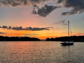
The river section is so different than the canal section. The canal is a cut with straight edges on either side while the river, in its natural state, twists and turns and offers a more pleasant vista. From this point south there are a lot of ox bows on either side of the waterway. An ox bow is a sharp, u-shaped bend in a river or meander of a stream or creek. Care must be taken when entering one looking for an anchorage. Although inviting, they can be deadly. Deadheads often block entrances and I'm sure are hidden below the surface just waiting for someone to make the mistake of turning into what looks like a peaceful inlet. Unlike on the canal or the divide cut, there are also a few neighborhoods along the river's edge. This is definitely a more picturesque section of the waterway.


Comments
Post a Comment