Day 134: November 29: The frosty cold morning gave way to a sunny day. Still waiting for our traveling buddies (David and Sandra on Zendeavor and Frank and Mona on Summer Fling) to meet up with us, we decided to stay put in Dewayne Hayes anchorage for the day (N33.35.746, W088.28.686).
Yesterday Sandra and David drove back from their home in Loxley, AL to Decatur where they left their boat. Today they will begin their travels from Decatur, heading towards us on the Tenn-Tom. David thinks he is about 3 to 4 days behind us, depending on time spent waiting on locks.
On Monday Frank and Mona arrived back from their Thanksgiving holiday in Michigan to Midway Marina where they kept Summer Fling for the week. They are waiting for a package to be delivered before getting UW. Fingers crossed it arrives today so they can get going.
We are doing our part to get the 3 boats back together by moving slowly, and sometimes, like today, not moving at all, giving our MIA friends time to catch up.
There is always something to do on a boat so aside from my time spent reading, window washing was on today's agenda. John required a bit of encouragement but I was successful! The trick is to start the project by myself; that usually works. Does he feel guilty? LOL.
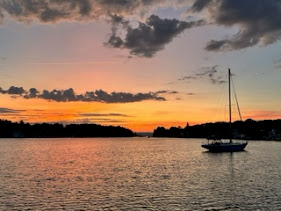
The slight breeze was enough to overcome the current and spin us around a few times throughout the day, one time facing toward the inlet, another heading out toward the river. John checked on things and found he could not see the trip line. An anchor trip line is a thin line with one or two plastic floats attached to one end and the other end clipped to the anchor. It is used to mark the position of the anchor and can help retrieve the anchor in case it gets stuck on the bottom. We searched around the boat and eventually saw the float; slightly visible around the stern close to the swim platform. This indicated that our stern had moved enough to be floating on top of the anchor. John got in the dinghy and attempted to spin the boat away, hoping to free the float and straighten out the boat. We were not successful; the boat would only move a bit before stopping; and it was getting dark so the attempt would have to wait until the morning. Hopefully we will not find that the line has gotten tangled in the prop although John allayed my concern, noting we have spar cutters which would take care of that kind of problem.
Tomorrow is another day!
Day 135: November 30: Overcast morning but we have hopes that the temperatures will improve (according to the weatherman). John got back in the dinghy hoping the boat had moved overnight and the trip line had freed itself. He tied a line to the stern and dragged the boat; it spun much more than last night which was a good sign. Success! The float popped up, freed from whatever obstruction had it submerged. Relieved, we prepared to get UW.
Traveling along the waterway can never be taken for granted. Care has to be taken when entering a cutoff as well as when simply cruising along. Debris including floating or submerged stumps and trees can ruin an otherwise good day. Just as we were ready to pull up the anchor we saw this good sized tree floating close by. A reminder to always be on the lookout!
Although the temperatures rose a bit, the sun remained hidden so we never really warmed up. Under dreary skies the waterway lost it brilliancy, browns and a muddy looking river taking over for the bluer than blue skies and crystal clear water. We know such gloomy days do pass and the sun will shine again.
In the meantime we saw a few large commercial enterprises; what appeared to be a grain elevator and another a recycling outfit. We continue to note the number of landings that are available to people on the river. However, we have not seen anyone using them; other than a handful of fishermen and Loopers, there has not been much boat traffic at all; I am reminded it is probably because of the season; it has been cold.
We knew we were approaching the Columbus Marina because we were getting AIS alerts; that is one downside of the Garmin system; it can be quite annoying with alarm after alarm going off, warning of boats, only to find they are not oncoming, only docked at a marina. John contacted the John C. Stennis Lock on channel 16; switch to 14. The Lock-master said he would turn the chamber round and be ready for us. We have been fortunate along this stretch of the waterway; tows and barges are far fewer than they were miles upstream. We locked through and were quickly on our way.
Quite a bit erosion exists along this stretch as well, requiring many houses to be built on stilts. I wonder how long it will take before some of them simply drop off into the water. There were also a couple of abandoned railroad bridges to nowhere! And I loved the little working tug named POP!
We only traveled 19.4 NM in just under 3 hours, stopping for the night at Hairston Bend Cutoff at Mile 318.5 (N33.20.635, W88.22.349) in Columbus, MS. We made our way carefully into the small entrance which opened into a huge body of water. We noted a couple of deadheads near a small island on the port side. Unsure of what else might be in further, we did not venture in too far and anchored in about 8 feet of water. We did not have good cell service but for some reason we were able to stream a movie on Prime. Who knew?


So cool
ReplyDelete